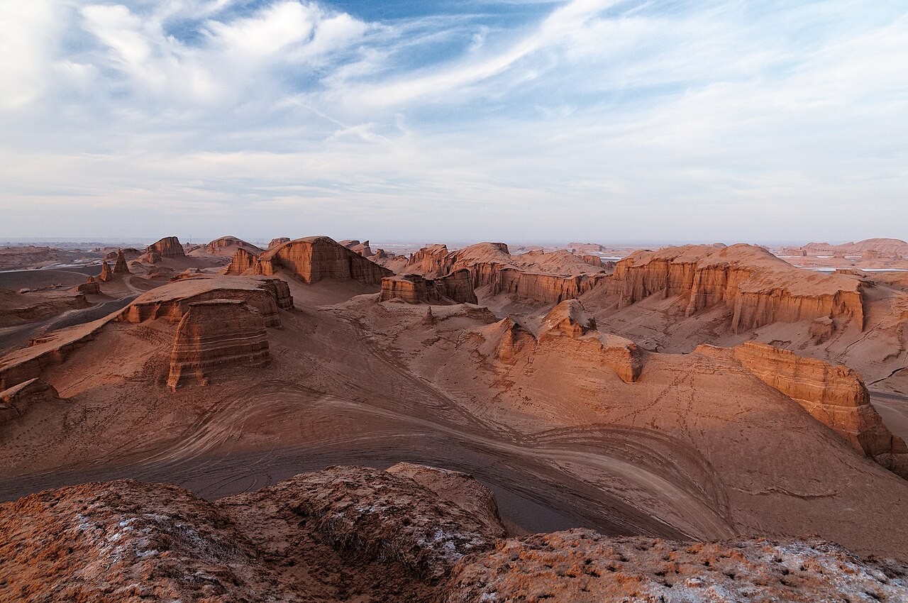
The Lut Desert does not welcome you the way a garden does. It does something stranger. You drive out of Kerman through date palms and pistachio country, the road climbs past the mountain village of Sirch, and then the land simply gives up its green. What remains is clay, salt, gravel, and a horizon so flat it feels drawn with a ruler. Then the kaluts appear: row after row of ridged towers rising from the plain like the ruins of a city that was never built by human hands. This is Dasht-e Lut, and it is one of the most extraordinary landscapes on the planet.
This guide covers everything you need for a real visit, whether you plan a long day trip from Kerman or a night under the stars. You will find out how to get there, when to go, what to see, how much is guided and how much you can do alone, and how to prepare for heat that has no equal anywhere on Earth.

Where is the Lut Desert?
The Lut Desert, known in Persian as Dasht-e Lut, spreads across the southeast of Iran. It touches three provinces: Kerman, South Khorasan, and Sistan and Baluchestan. The desert covers an area of roughly 51,800 square kilometers, which makes it one of the largest deserts in the Middle East and about the size of Costa Rica . The name itself comes from a word meaning bare, empty, and without water, and the name is honest.
The part that almost every visitor sees is the western edge, in Kerman Province. The town of Shahdad sits about 90 to 100 kilometers northeast of Kerman city, and the kalut fields begin roughly 40 kilometers beyond Shahdad along the road toward Nehbandan . This is the accessible face of the Lut, the section with paved approach roads, a ranger post, camps, and guides. The deeper desert, the central chaleh and the great dune fields, is a different undertaking entirely and should never be attempted without an experienced local team.
For orientation: Kerman is the natural base. Yazd and Isfahan are both long drives away. The nearest airports with useful connections are Kerman and, for some travelers, Bam further south.
Why the Lut Desert Matters
In 2016, the Lut Desert became the first natural site in Iran to be inscribed on the UNESCO World Heritage List . The listing recognized a set of geological phenomena found almost nowhere else at this scale: the yardangs that locals call kaluts, vast salt flats, and some of the tallest sand dunes on Earth, reaching nearly 475 meters .
The desert also holds a more uncomfortable distinction. Satellite measurements have recorded surface temperatures here above 70 degrees Celsius, among the highest ever measured on the planet . The central plateau known as Gandom Beryan, meaning roasted wheat, has been described for years as the hottest point on Earth. Treat that claim with the caution it deserves, since temperature records are contested and depend on how and where they are measured, but do not treat the heat itself lightly. It is real, and it is dangerous.
Archaeology adds another layer. Excavations south of the kaluts have uncovered bronze and pottery objects dating to the second and third millennium BCE, suggesting that a settlement once existed here and was swallowed by a changing climate . Standing among the kaluts, it is not hard to believe.
How to Get to the Lut Desert
Almost every journey begins in Kerman. The drive from Kerman to Shahdad is about 90 kilometers on paved road and takes roughly an hour and a half depending on traffic leaving the city . From Shahdad, the kalut area lies a further 40 kilometers or so along the Shahdad to Nehbandan road .
For the first leg, the cleanest option is to open Mehyar and book a Mehyar Taxi from your hotel in Kerman to Shahdad. That covers the paved highway comfortably and lets you travel on your own schedule rather than waiting for a shared vehicle. If you are arriving in Kerman by air, Mehyar Taxi also handles the airport transfer, so you can land, settle in, and plan the desert run the next morning.
Once you reach the kalut zone, the story changes. The final stretch is unpaved, soft in places, and genuinely easy to misjudge. Google Maps has routed travelers into salt crust that nearly swallowed a four-wheel-drive vehicle, and the local guides' waypoints are the only reliable map . This is not a place to test your navigation instincts.

Guided Tours and 4x4 Options
For the kalut fields and anything deeper, a local guide with a four-wheel-drive vehicle is not a luxury. It is the sensible way to go, and for the orange and red zones it is effectively mandatory. Local 4x4 hire with a driver runs in the range of several million Iranian rials per day, and you should expect to pay in cash, since cards are useless in the desert towns .
The Shahdad eco-guard post logs vehicle plates before entry, so register there even if you are traveling independently in the green zone . Local operators in Shahdad and Kerman arrange half-day and full-day kalut tours, sunset and sunrise trips, and overnight camping with dinner. If you prefer to keep logistics in one place, Mehyar's planner and our Kerman articles can help you build the day around your arrival and departure, and Mehyar Taxi can position you in Shahdad before your guide takes over.
What a good tour includes: pickup in Kerman or Shahdad, a 4x4 with a driver who knows the tracks, water, and enough time among the kaluts to walk, photograph, and simply stand still. What it should not include: pressure to race between viewpoints. The desert rewards patience.
The Kaluts: A City Made by Wind
The kaluts are the reason most travelers come. The word is local, and the scientific term is yardang: ridges and towers of clay, sand, and salt carved by wind and water over roughly 20,000 years . The kalut field stretches about 145 kilometers from north to south and around 70 to 80 kilometers from east to west . Ridges run for tens of kilometers, and individual towers reach 80 meters and more .
Walking among them is the point. The towers are striped with pale and dark layers, so they look like sliced cake or stacked sediment made visible. Their windward faces are steep and their leeward faces gentler, which is the signature of the wind that shaped them. There is no vegetation inside the core field, no sound beyond your own footsteps and the breeze, and no shade. Foreign travelers have long called this the city of ghosts, and the name fits.
Plan your visit around the light. Sunrise and sunset are when the kaluts turn from gray to gold to deep orange, and the shadows between the ridges stretch and sharpen . Midday is harsh, flat, and punishing. If you can only manage one visit, choose late afternoon into dusk, and stay for the stars if your guide and vehicle allow it.
The Green, Orange, and Red Zones
To protect visitors and the fragile landscape, the Shahdad kalut area is divided into three zones.
The green zone covers the first two kilometers along the Shahdad to Nehbandan road . It is open to the public, no permit is required, and the basic facilities, shelters, and services sit here. This is where most casual visitors experience the kaluts, and it is genuinely impressive even without going further.
The orange zone lies beyond the green and requires an off-road vehicle, a local guide, and real desert experience . Entry is regulated because the risk of getting lost is high.
The red zone is the deepest and is closed to ordinary tourists. Only specialist teams with specific permits enter .
The rule is simple. If you want to see the wilder kaluts and the dune fields, go with a guide. If you only have a few hours and no four-wheel-drive, the green zone still delivers the essential Lut experience.

What Else to See in the Shahdad Area
Beyond the kaluts themselves, the Shahdad section of the Lut holds several features worth building into your day.
The Shur River is the only permanent river running through the heart of the Lut, rising in the mountains near Birjand and flowing roughly 200 kilometers before ending near Shahdad . Its water is extremely salty and undrinkable, but watching a river move through one of the hottest places on Earth is its own kind of strange.
Salt polygons, the hexagonal salt patterns that form around salt lakes and flats, appear near the kalut edges and make striking photographs . The salt marshes of Shahdad cover about 100 hectares and have a bubbling, eggshell-like texture that is unusual even by desert standards .
Nabkha are the natural sand planters you will notice on the margins of the kalut field. Tamarisk bushes trap windblown sand until they sit on top of small dunes, looking like enormous potted plants set out across the plain . They mark the last reach of vegetation before the truly empty ground begins.
If you are lucky, or unlucky depending on your view of heat, you may pass near Gandom Beryan, the roasted wheat plateau that has been measured at surface temperatures above 70 degrees Celsius . It is not a place to linger.
Best Time to Visit and the Heat Danger
The best time to visit the Lut Desert is from October through March . November through February is the sweet spot, with mild days and cold nights, suitable for hiking, camping, and photography . Spring, particularly late March and April, works too, though the Nowruz crowds can be heavy. The desert is officially closed to visitors in summer, and that closure exists for good reason .
The heat here is not ordinary heat. Summer surface temperatures have exceeded 70 degrees Celsius, and some spots have approached 80 degrees . Shoe soles can soften, plastic warps, and breathing feels like standing in front of a running hairdryer . Even in the cooler months, daytime temperatures can reach around 30 degrees, and the night can drop sharply, so you need both sun protection and a warm layer .
What to bring, without negotiation: more drinking water than you think you need, salty snacks and full meals, a hat, sunglasses, sunscreen, closed walking shoes, a warm jacket for the night, a flashlight, and a charged phone or power bank . Travel with a guide or a registered tour, share your route, and never drive off designated tracks. The ecosystem is fragile and the penalties, physical and legal, are real .
Staying Overnight in the Desert
An overnight stay transforms the visit. Once the sun drops, the heat lifts, the sky opens, and the light pollution is essentially zero. Travelers describe watching Orion settle onto a kalut ridge and the Milky Way pour overhead . Camping at the kalut edge is possible in the free, no-facility sense, provided you carry out everything you bring in .
If you want comfort, the Shahdad area now has options. The Star of Lut eco-camp near the village of Malekabad opened with dozens of tented units built to blend with the desert, and it has raised the standard of accommodation in the region . There are also numerous eco-lodges and a traditional hotel in and around Shahdad, plus a desert camp with palm-frond shelters on the Shahdad to Nehbandan road . During peak seasons such as Nowruz, demand is high, so reserve well ahead through Mehyar Hotels rather than arriving and hoping.
If you would rather sleep in a bed and drive out for the evening, Kerman has the widest choice of hotels, and a Mehyar Taxi can collect you after sunset and bring you back. For more on the region, see our guide to Kerman.
Practical Notes and Safety
Travel in the Lut is about respect as much as preparation. Tell someone your route. Register at the eco-guard post. Carry cash, because card readers do not work out here . Do not pick up rocks or disturb formations. Do not leave trash. Do not wander alone into the orange or red zones.
If you are combining the desert with the rest of the province, our article on Kerman covers the city's bazaar, the Ganjali Khan complex, and the gardens at Mahan. If you want to sleep under the stars elsewhere in Iran first, read our piece on desert camping in Iran. And if you are comparing desert seasons across the country, our guide to the best time to visit Iran will help you place the Lut in a wider itinerary. Varzaneh is a gentler desert introduction near Isfahan and works well as a warm-up.

Closing: A Place That Changes You
The Lut Desert is not a comfortable destination, and it is not meant to be. It is a place of scale and silence, where a river runs salt through the hottest ground on Earth and where wind has spent twenty thousand years building a city that no one will ever live in. You come for the kaluts, and you leave thinking about distance, patience, and how small a person is against a horizon with no end.
Start your planning in Mehyar. Book your Kerman hotel, arrange a Mehyar Taxi to Shahdad, and use the planner to lock in a guided 4x4 for the kaluts. Go in the cool months, carry more water than feels reasonable, and let the desert set the pace.