
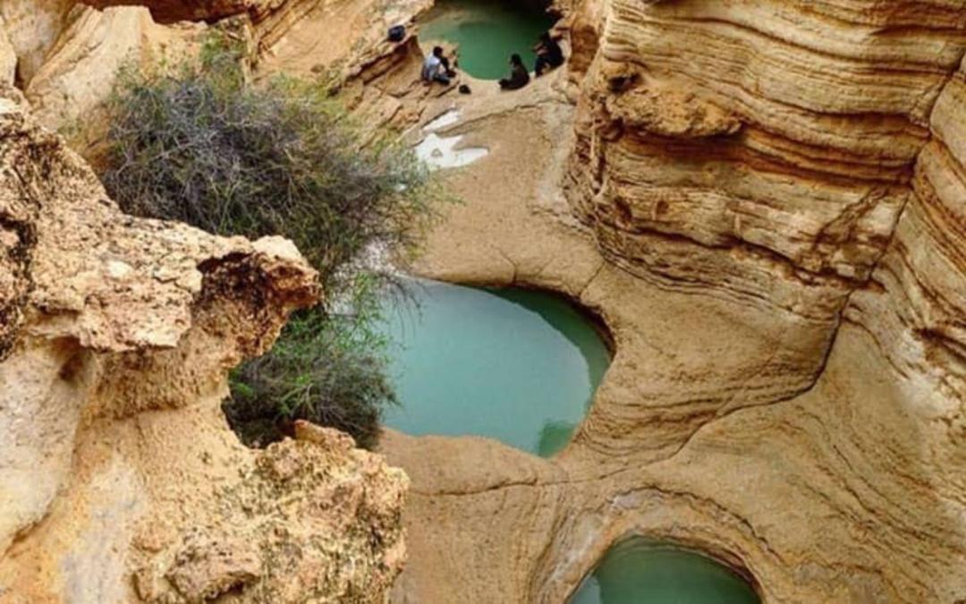
When most people think of Iran, desert landscapes and ancient mosques come to mind. But on Qeshm Island, in the warm waters of the Persian Gulf, a completely different Iran reveals itself — one of eroded canyons that rival the American Southwest, salt caves that stretch for kilometres underground, and valleys where the rocks look like they were sculpted by alien hands. This is Qeshm Geopark, the very first UNESCO Global Geopark in the entire Middle East, and it remains one of Iran's most astonishing natural wonders.
Where Is Qeshm Geopark?
Qeshm Geopark sits on the western portion of Qeshm Island in Hormozgan Province, southern Iran. Qeshm itself is the largest island in the Persian Gulf, covering roughly 1,500 square kilometres. The island occupies a remarkable geographical position at the junction of two distinct marine ecosystems — the Persian Gulf and the Gulf of Oman — connected through the Strait of Hormuz. Despite their proximity, these two bodies of water harbour dramatically different marine life, and this confluence gives Qeshm an ecological richness that few places on Earth can match.
The geopark's core area initially covered 300 square kilometres of western Qeshm when it first received UNESCO recognition. That area has since expanded significantly to over 2,063 square kilometres, incorporating the entire island, the Hara Marine Forests to the north, and neighbouring Hengam Island.
What Exactly Is a Geopark?
A geopark is not simply a protected nature reserve. The concept, managed through UNESCO's Earth Sciences division, aims to integrate geological conservation with sustainable community development. Unlike many protected areas that restrict visitor access, geoparks are specifically designed for public engagement — they invite people in, educate them about Earth sciences, and generate sustainable economic opportunities for local populations.
The Global Geoparks Network was established in 2004, beginning with 17 European and 8 Chinese founding members. By 2020, it had grown to 161 geoparks across 44 countries. Qeshm Geopark holds a singular distinction within this network: it is both the first geopark in the Middle East and Iran's only UNESCO-recognised geopark.
A Turbulent History of Recognition
Qeshm Geopark was first inscribed on the UNESCO Global Geoparks list in 2006, at the Paris session of the network. It was among the earliest members and immediately drew international attention for its extraordinary geological diversity.
However, the geopark's journey has not been smooth. In 2012, UNESCO removed Qeshm from the global list after local authorities in the Qeshm Free Zone failed to meet the management and conservation standards required for membership. It was a significant blow — and a cautionary tale about the fragility of international conservation designations.
Persistent efforts by Iranian cultural heritage organisations eventually paid off. In May 2016, Qeshm Geopark was re-inscribed as a UNESCO Global Geopark for a four-year term, marking a triumphant return to the international stage. Yet challenges have persisted. In 2019, the allocation of lands within the Namakdan Salt Cave area for commercial development — including an aquaculture facility and industrial zones — once again raised concerns from international bodies about the geopark's long-term protection.
The 25 Geosites
Qeshm Geopark encompasses 25 designated geosites, each representing a different facet of the island's geological, ecological, or cultural heritage. Here are the most significant ones.
Namakdan Salt Cave (غار نمکدان)
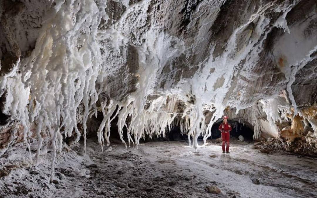
One of the seven wonders of Qeshm, the Namakdan Salt Cave was registered on Iran's National Natural Heritage list in 2011. Located approximately 100 kilometres from Qeshm city, the cave forms within a massive salt dome that has pushed upward through the Earth's crust over millions of years. The cave system holds the distinction of containing the longest salt cave passage in the world. Inside, visitors encounter extraordinary crystal formations, salt stalactites, and corridors that glow with an otherworldly luminescence.
Star Valley (دره ستارگان)
Perhaps Qeshm's most photographed natural feature, Star Valley is a landscape of eroded sandstone pillars, columns, and spires that rise from a narrow canyon floor. The local population believes that when a star fell from the sky, it created this surreal terrain. The formations resulted from millions of years of wind and water erosion acting on layers of sedimentary rock with varying hardness, producing shapes that shift and surprise at every turn. Walking through Star Valley feels like navigating a stone forest.
Chahkooh Canyon (تنگه چاهکوه)
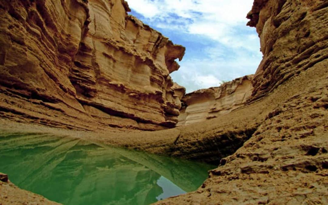
Located southwest of the village of Chahoy-e Sharqi, Chahkooh Canyon consists of two intersecting narrow gorges carved into the island's limestone bedrock. The canyon walls display an extraordinary array of erosional features — holes, crevices, grooves, and undulating patterns that look impossibly smooth. After rainfall, water collects in the canyon floor, and local residents historically dug wells (chah in Persian) into the rock to harvest this precious water, giving the canyon its name: "Well Mountain."
Korkorakuh (کورکورا کوه)
Situated east of the village of Giahdan, Korkorakuh features rolling hills and ridges that have been deeply carved by seasonal water flow, creating narrow passages known locally as "bad-bom" — natural corridors where wind channels through the rock formations and creates an eerie, musical sound.
Valley of Statues (دره مجسمهها)
Similar in geological character to Star Valley but considerably larger, the Valley of Statues features rocks sculpted by erosion into forms that resemble enormous figures and monuments. The surface is largely covered with mud-crack patterns, and the scale of the formations dwarfs visitors who walk among them.
Hara Marine Forests (جنگلهای حرا)
The Hara Forests are a UNESCO-registered biosphere reserve consisting of halophytic (salt-tolerant) mangrove trees that thrive in the intertidal zones along Qeshm's northern coast. These remarkable trees grow with their roots submerged in saltwater, creating a lush green landscape seemingly floating on the Persian Gulf's blue waters. The forests cover more than 100,000 hectares and serve as critical habitat for numerous bird species, fish, and marine invertebrates.

Laft Historical Village (روستای لافت)
On Qeshm's northwestern tip, Laft village preserves centuries of maritime heritage. The village is known for its distinctive badgirs (wind catchers), traditional wooden boat-building yards, and the ruins of a Portuguese fort from the 16th century when the Portuguese briefly controlled the island.
Kharbas Cave (غار خربس)
These caves near the southern coast feature both natural geological formations and ancient human modifications. Some chambers show evidence of habitation dating back thousands of years, while local legends connect them to various mythological narratives.
Biodiversity Beyond Geology
Qeshm Geopark's significance extends well beyond its geological features. The island sits at the meeting point of two marine ecosystems and hosts an extraordinary range of coastal habitats — rocky shores, coral reefs, sandy beaches, mangrove forests, and tidal zones — all within a single compact area. This concentration of coastal ecosystem types is unique throughout the entire Persian Gulf region.
The coral reefs surrounding Qeshm support diverse marine life, while the island's beaches serve as nesting grounds for endangered sea turtles, particularly the hawksbill and green turtles. The tidal zones teem with crabs, molluscs, and wading birds.
The island's terrestrial vegetation includes native species such as Konar (Ziziphus), Prosopis, and various drought-adapted shrubs. Bird-watchers will find the geopark rewarding, with numerous migratory and resident species inhabiting the wetlands and coastal areas.
When to Visit
Qeshm Island has a semi-tropical climate, meaning it is hot and humid for much of the year. The most comfortable time to visit is between October and April, when temperatures are moderate and the weather is generally pleasant for outdoor exploration. The spring months — particularly March and April — are ideal, as wildflowers bloom across the island's interior and the light is perfect for photography.
Summer months from May through September can be punishingly hot, with temperatures regularly exceeding 40°C and humidity levels that make outdoor activity exhausting. If you visit during this period, plan your explorations for early morning and late afternoon, and always carry plenty of water.
Getting There
Reaching Qeshm Island is straightforward. Fly into Qeshm International Airport from Tehran or other major Iranian cities, or take a ferry from the mainland port of Bandar Abbas. Once on the island, the geopark's various geosites are spread across its surface, and you will need transport to move between them.
By Mehyar Taxi. The most flexible way to explore the geopark's scattered geosites is with a Mehyar Taxi. Your driver knows the terrain, can navigate between sites efficiently, and waits while you explore each location at your own pace.
By Mehyar Buses. Intercity Mehyar bus services connect Bandar Abbas and other southern cities to Qeshm ferry terminals, making overland travel from anywhere in Iran accessible and affordable.
By organised tour. Several local operators offer full-day geopark tours covering the major geosites with an English-speaking guide — an excellent option for first-time visitors who want geological context for what they are seeing.
Practical Tips for Visitors
The geopark itself has no entrance fee, though some individual sites may charge a small access charge. Wear sturdy walking shoes — the terrain is uneven and the rock surfaces can be sharp and slippery. Bring sun protection regardless of the season, as shade is scarce in most of the canyon and valley environments. Photography enthusiasts will find the golden hours around sunrise and sunset produce the most dramatic lighting on the rock formations.
Local guides are available at major geosites and their knowledge significantly enriches the experience. Many geological formations require interpretation to appreciate — what looks like a random collection of rocks becomes a narrative of millions of years of Earth history when explained by someone who understands the landscape.
Qeshm Geopark is not just a destination — it is a window into the forces that shaped the Earth's surface, presented on a scale and with a diversity that few places on the planet can offer. As the Middle East's pioneer UNESCO Global Geopark, it deserves far more attention than it currently receives from international travellers. For those willing to venture south to the shores of the Persian Gulf, it rewards with experiences that are genuinely unlike anywhere else.