
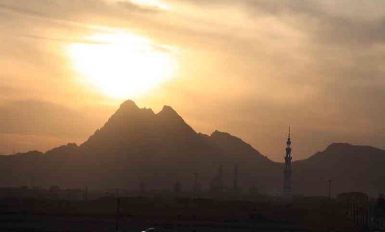
When you stand in the streets of Qom and look to the southeast, your eye catches a ridge of dark rock that rises abruptly above the flat alluvial plain. That ridge is Kuh-e Dobradran, the Mountain of Two Brothers, and it is the most popular climbing destination in Qom Province. The mountain has two summits side by side, a lower peak and a higher one, and the trail to the top passes through rocky gullies, past wild caper bushes, and along ridgelines that offer sweeping views over the city of Qom and, on clear days, as far as the salt flats to the south.
Dobradran is not a gentle walk. The standard route takes roughly one hour to the summit and involves scrambling over loose rock and pulling yourself up short cliff bands with your hands. The south face is a proper rock wall that only experienced climbers should attempt. But the northwest approach, which most hikers use, is manageable for anyone with a reasonable level of fitness and a pair of sturdy boots. The reward at the top is a panorama that stretches across the entire Qom plain, with the golden dome of the Holy Shrine visible far below on one side and the rugged line of the Qom Mountains running along the horizon on the other.
This guide covers where Dobradran sits in relation to Qom, how to reach the trailhead from Tehran and from within Qom, what the climb is actually like, the best time to go, and how to fit the mountain into a day trip that can also include the shrine, the bazaar, and other sights in the city.
Where is Dobradran Mountain?
Kuh-e Dobradran sits roughly eight kilometres southeast of the centre of Qom, in the foothills that mark the northern edge of the central desert plateau. The mountain rises to an elevation of approximately 1,240 metres above sea level, which does not sound high until you remember that the city of Qom itself sits at around 870 metres. The gain is therefore close to 370 vertical metres over a horizontal distance of less than two kilometres, and that steepness is what gives the mountain its character.
The nearest urban landmark is the Jamkaran Mosque, which lies at the eastern edge of Qom and is itself a major pilgrimage destination. The trailhead to Dobradran begins in the hills above and to the southeast of Jamkaran, and you can see the two summits clearly from the mosque courtyard. The area falls within Qom Province, in central Iran, roughly 125 kilometres south of Tehran by road.
Geographically, Dobradran belongs to the Qom Range, a chain of limestone and volcanic hills that runs east to west across the northern part of the province. These hills are the surface expression of a geological fold belt that continues underground beneath the Dasht-e Kavir, the great salt desert that covers much of central Iran. The rock underfoot on Dobradran is a mix of sedimentary limestone and older volcanic formations, which is why the lower slopes are gentler and the upper sections break into crags and cliff bands.
How to get to Dobradran Mountain
The most common approach is from Tehran, since most international visitors to Iran pass through the capital. Tehran to Qom is a distance of about 125 kilometres, covered in ninety minutes to two hours depending on traffic. Here are the main options.
By Mehyar Taxi. The simplest way to reach the Dobradran trailhead from Qom is to open Mehyar, choose Taxi, and set your destination to the mountain or to Jamkaran Mosque as a waypoint. A private car with a driver who knows the roads gives you flexibility to stop at viewpoints along the way and to wait while you complete the climb. From Tehran, you can use Mehyar Taxi to reach Qom first, or take a bus and then switch to a local Mehyar ride for the final leg to the trailhead.
By Mehyar Buses. For budget travellers, Mehyar Buses connects Tehran to Qom frequently throughout the day. The buses depart from the southern terminals in Tehran and arrive at the Qom bus station in roughly two hours. From the bus station, you can take a local taxi or a Mehyar ride to the Jamkaran area and begin the hike from there.
By private car. If you are driving, take the Tehran-Qom freeway south, exit at the Qom ring road, and follow signs toward Jamkaran. Parking near the trailhead is informal, typically on the shoulder of the access road. Ask locals for the exact starting point, as signage is minimal.
By train. Qom has a railway station on the Tehran-Isfahan line. Trains run several times a day. From Qom station, take a taxi to the Jamkaran area, which is about a fifteen-minute drive.

What to see and do on Dobradran Mountain
The climb itself is the main attraction, but the mountain offers more than just physical exertion. Here is what you will encounter on the way up and at the top.
The trail and the terrain. The standard northwest route begins on a faint dirt track that winds up through low scrub and scattered boulders. As you gain height, the vegetation thins out and the path becomes a rocky scramble. In places you will need to use your hands to pull yourself up ledges of limestone. The rock is generally solid but can be slippery when wet, so avoid the mountain after rain. The trail is not marked with paint or signs, which is why it helps to follow the line of the two peaks and to ask locals for the starting point.
The twin summits. The lower peak is reached first and offers a good resting point with views back toward Qom. The higher peak, which is the true summit at roughly 1,240 metres, requires a short additional scramble along a narrow ridge. Standing on top, you can see the entire Qom plain spread out below you, with the Holy Shrine complex at its centre. On a clear day, the view extends south toward the salt lake and east toward the higher mountains of the Qom Range.
Wildlife and flora. The slopes of Dobradran are home to a variety of hardy desert-adapted plants, including wild caper, thorny burnet, and several species of astragalus. In spring, after the rains, the lower hillsides can briefly turn green with annual wildflowers. Birdlife includes houbara bustard, chukar partridge, and various raptors that ride the thermals above the ridgelines.
Photography. The light on Dobradran is best in the early morning or late afternoon, when the low sun throws long shadows across the rock faces and the city below is bathed in warm tones. Sunrise from the summit is spectacular, though it requires a predawn start and a headlamp for the descent in the dark.
The south face. Experienced rock climbers may be interested in the south face of Dobradran, which presents a technical challenge with steep rock walls and exposed climbing. This route is not for casual hikers and should only be attempted with proper equipment and knowledge of rock climbing techniques.

Best time to visit Dobradran Mountain
The climate around Qom is semi-arid, with hot summers and cool winters. The best seasons for hiking Dobradran are spring and autumn.
Spring (March to May) offers the most pleasant conditions, with daytime temperatures in the teens and low twenties Celsius. The hillsides may still have some green vegetation from winter rains, and the wildflowers can be outstanding in March and early April. Nights are cool but not cold.
Autumn (late September to November) is equally good, with clear skies, comfortable temperatures, and excellent visibility for the panoramic views from the summit. The summer heat has broken, and the air is generally dry and crisp.
Summer (June to August) is best avoided for a midday hike. Temperatures in Qom regularly exceed forty degrees Celsius, and the exposed rock of Dobradran radiates heat. If you must climb in summer, start before sunrise and aim to be back down by mid-morning.
Winter (December to February) can bring cold winds and occasional snow at this elevation. The climb is still possible on clear days, but the rock can be icy and the daylight hours are short. Bring warm layers and check the weather forecast before setting out.