
Iran does not fit into one itinerary. It fits into regions, and each region keeps its own reasons for demanding a trip: an Achaemenid ceremonial plateau in the south, a mud-brick ziggurat on the Khuzestan plain, a Safavid square in the centre, Parthian and Ilkhanid domes in the northwest, the largest earthen citadel in the world on the edge of the Lut Desert, and a forest older than the mountains beside it along the Caspian. What links these twenty sights is continuity rather than style. Several were built, burned, rebuilt and used again across two and a half thousand years. Plan two or three regions per trip.
Where are these sights?
Six clusters organize the country. Fars holds Persepolis, Pasargadae, Naqsh-e Rostam and the circular Sasanian city at Firozabad, all within reach of Shiraz. Khuzestan holds Chogha Zanbil and the Shushtar hydraulic system. Central Iran holds Naqsh-e Jahan and the Jameh Mosque of Isfahan. The northwest holds Takht-e Soleiman, Soltaniyeh and Gonbad-e Kavus. Kerman holds the Arg-e Bam and the Shazdeh Garden at Mahan. Tehran holds Golestan Palace, Ardabil the Sheikh Safi complex, Kermanshah Bisotun, and the Caspian the Hyrcanian forests. Three inhabited landscapes close the list: the terraced Kurdish villages of Uramanat, the rock-cut houses of Maymand, and the Bronze Age city of Shahr-e Sukhteh in Sistan.
Persepolis, Pasargadae and Naqsh-e Rostam

About sixty kilometres north of Shiraz, the Achaemenid kings laid their ceremonial capital on a leveled stone terrace. Persepolis is roughly 2,500 years old, and you enter by a stepped ramp into an open space ringed by halls: the Gate of the Nations with its tall mud walls and four colossal columns, the treasury, the Hall of a Hundred Columns, the palace of Xerxes called Hadish, the Palace of Three Doors, the great Apadana audience hall, the private palace of Darius named Tachara, and the royal tombs cut into the cliff above. One detail stays with visitors. When slavery was the default in every major empire, the builders of these palaces were salaried workers with recorded rights and rations.
North of the terrace road sits Pasargadae, the tomb of Cyrus and the garden that set the pattern for the Persian garden for two millennia. At Naqsh-e Rostam, Sasanian reliefs are carved into a vertical wall beneath cross-shaped royal tombs, which is where the artwork survives best.
Chogha Zanbil and the waterworks of Shushtar
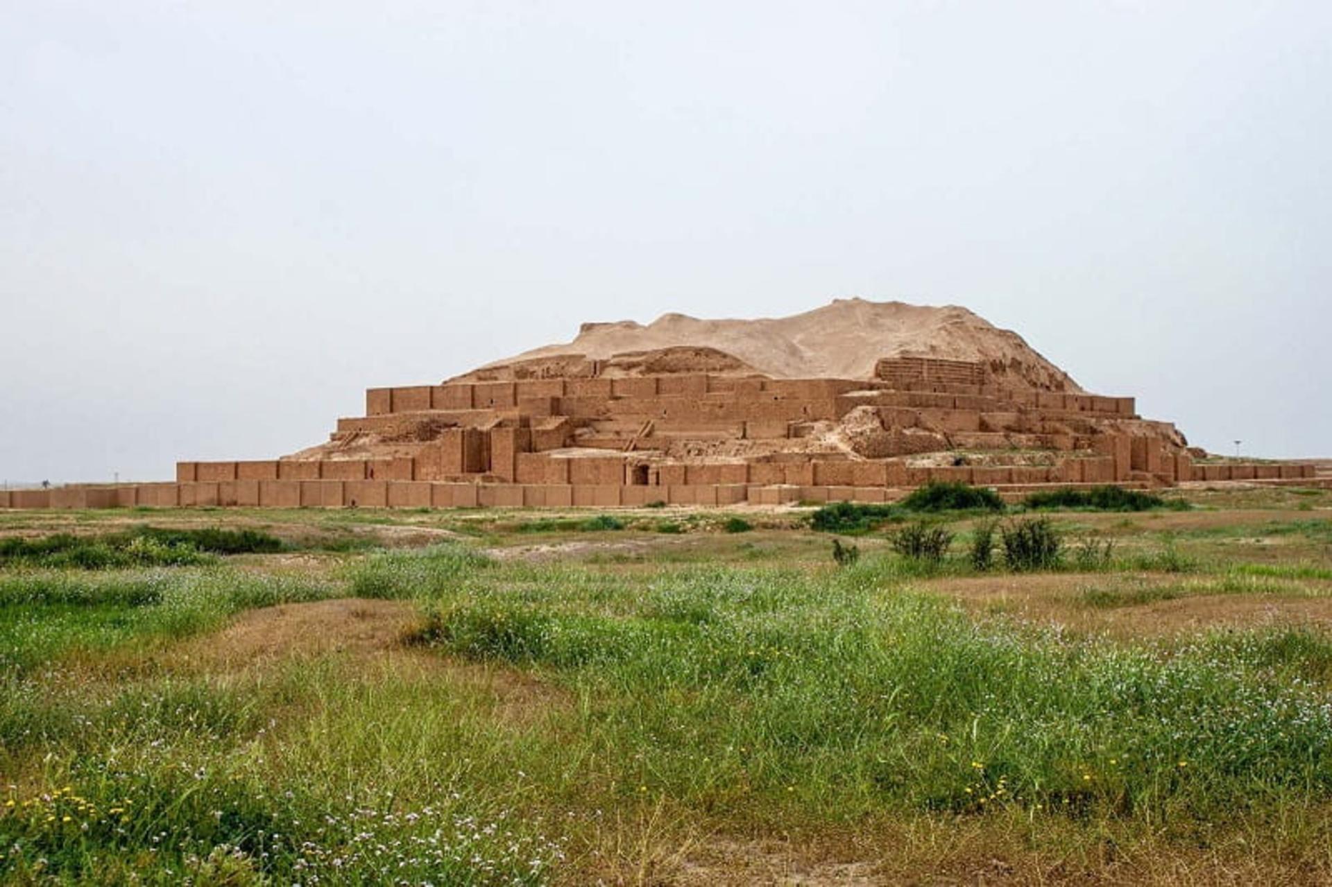

Chogha Zanbil was the first Iranian site inscribed by UNESCO. The complex covers some 100 hectares, and its ziggurat rose in five tiers from a base of 105 by 105 metres toward an original height near 52 metres. Roughly 25 metres survive, stacked like concrete that set mid-pour, and it is still the best-preserved ziggurat outside Mesopotamia. Ashurbanipal destroyed the city in 640 BC, which is why nothing later was built on top of it.
Nearby, the Shushtar historical hydraulic system shows what a Sasanian engineer could do with a river. Extended under Ardashir I and Shapur I, it uses diversion weirs, canals, tunnels, rock-cut channels and mill chambers to hold back the flood of the Karun and drive water into irrigation ditches. It is the most complete scheme of its period anywhere.
Naqsh-e Jahan and the Jameh Mosque
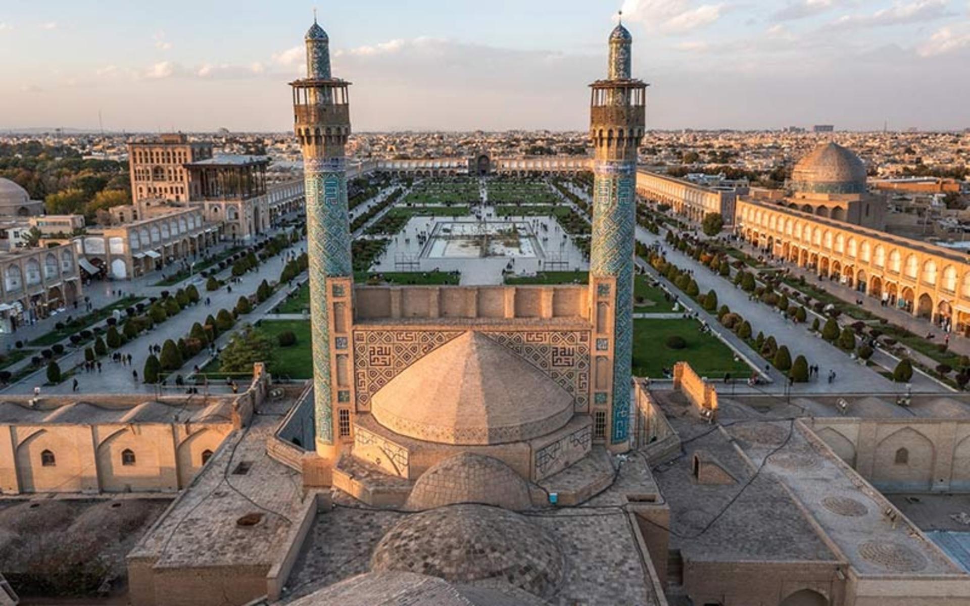
Naqsh-e Jahan Square, also called Imam Square, is one of the largest urban squares on earth: over 500 metres long, about 160 wide, ringed by two hundred two-storey compartments. Shah Abbas I laid it out to pull the Safavid capital south along the Zayandeh River, and building ran from 1011 to 1025 AH. Four monuments anchor the sides: the Imam Mosque to the south, the Sheikh Lotfollah Mosque to the east, Ali Qapu palace to the west, and the Qeysarieh gate to the north, opening into the covered bazaars. Two old goal posts from the polo game choghan still stand on the lawn, because the square began as a field.
Ten minutes on foot, the Jameh Mosque of Isfahan is the oldest historical building in the city, its present character set in the Seljuq era, extended under the Safavids, with Buyid remains from the third century AH beneath the floor. Built on the four-iwan plan and repaired after repeated fires, it reads as a continuous record of Iranian religious architecture: the courtyard, the north and south domes, the Oljeitu mosque and mihrab, the winter hall and the library endowed by Nizam al-Mulk.
Takht-e Soleiman, Soltaniyeh and Gonbad-e Kavus
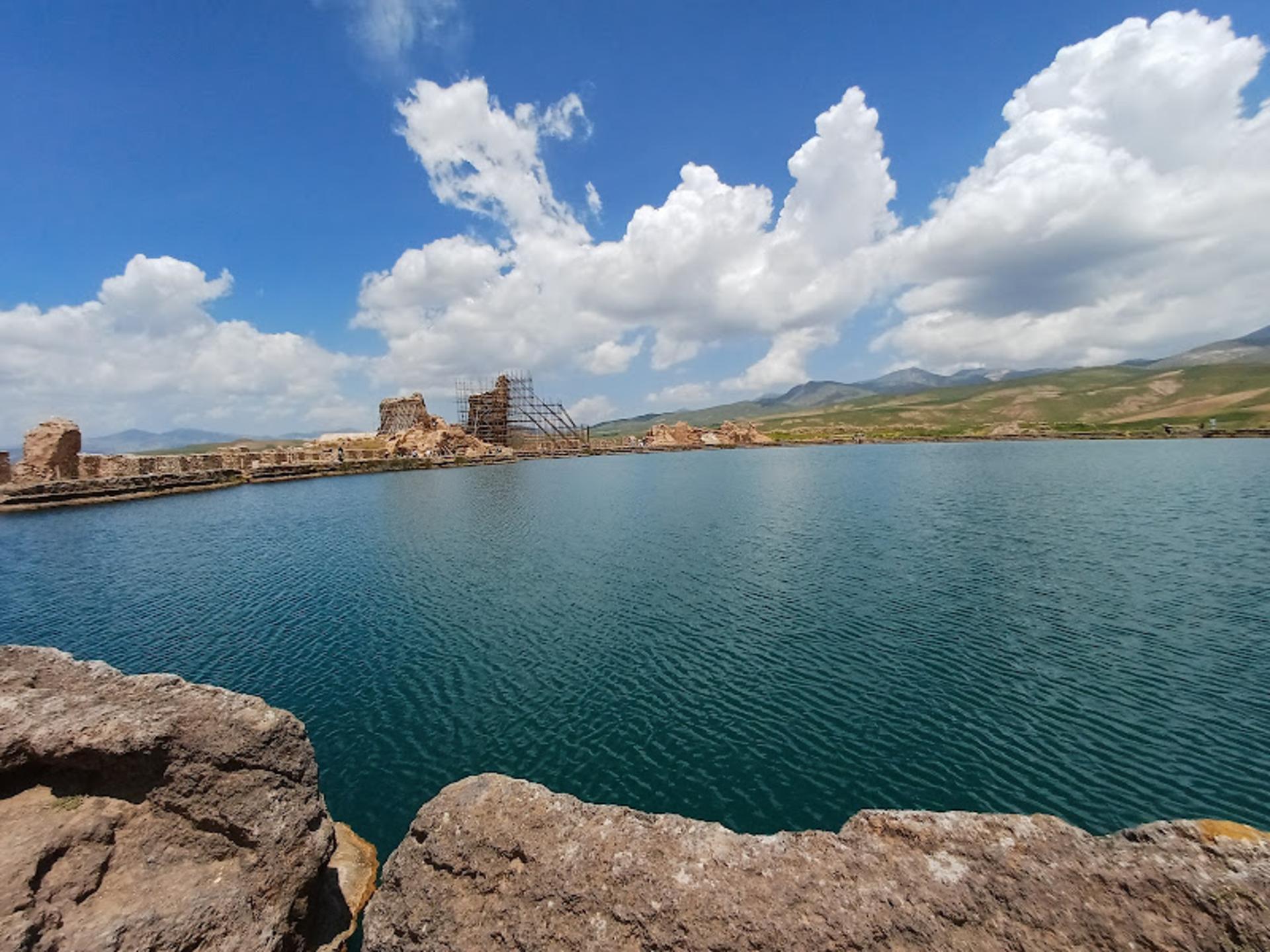
Takht-e Soleiman, in the mountains of West Azerbaijan, has been occupied for some 3,000 years by five civilizations around a walled lake fed by a deep artesian spring. Its Sasanian and Parthian walls enclose the Zoroastrian fire temple associated with Bahram V and the great Azar Goshnasb fire. Most stone sites are static; this one is not, because the water still moves.
Near Zanjan, the dome of Soltaniyeh was built between 704 and 712 AH for the Ilkhanid ruler Oljeitu. It stands about 50.48 metres with a drum near 40.24 metres across, the largest brick dome in the world and the ancestor of every dome you admire later in Isfahan. On the Turkmen plain in Golestan, Gonbad-e Kavus is older still: a 397 AH Ziyarid tower of some 70 metres including its conical cap, raised without supports or beams and still standing after two earthquakes above 7 on the Richter scale.
Bam, Mahan, Golestan and Ardabil
The Arg-e Bam sits where the Lut Desert begins and was the largest mud-brick city on earth until the earthquake of 1382 AH. Its walls once ran six to seven metres thick around some 18,000 square metres of citadel, and the rebuilding since lets you watch a heritage site come back course by course. At Mahan nearby, the Shazdeh Garden is a Qajar princely garden of 5.5 hectares, laid out between 1298 and 1309 AH around the Naserdoleh pavilion, with a stepped water channel dropping the length of the terraces.
In Tehran, Golestan Palace covers 4.5 hectares, a tenth of the original compound, and housed the Qajar shahs from Agha Mohammad Khan to Ahmad Shah; its Marble Throne iwan predates the dynasty and belongs to Karim Khan Zand. In Ardabil, the shrine complex of Sheikh Safi al-Din gathers buildings raised between 735 and 1038 AH around the graves of the sheikh and Shah Ismail I, from the entrance portal and chandelier hall to the Paradise Hall and the dome. No other site shows the Ilkhanid to Safavid sequence so completely.
Bisotun and Firozabad
Bisotun, outside Kermanshah, covers 1,650 hectares and holds 28 national monuments in one frame, from Elamite sculpture through Median, Achaemenid, Parthian and Sasanian remains. The centerpiece is the trilingual inscription of Darius I, which unlocked cuneiform and earned the site its UNESCO listing. Beside it sit the Hunter's Cave carvings, the investiture relief, the statue of Herakles and the Farhad Tarash channel. At Firozabad, Ardashir-Khwarrah, the City of Gur, is a circular Sasanian capital of 1,469 hectares whose rings and radial streets were planned in one campaign, with the palace of Ardashir and Qala Dukhtar above it.
Forests and living villages
The Hyrcanian forests, shared with Azerbaijan and listed as natural heritage, run along the Caspian rim through six provinces. Geologists put their age near 40 million years. They cover 1.25 million hectares, barely one percent of Iran, and only a tenth of that is protected: Almistan near Amol, Abr near Shahrud, Bula near Sari, Kajur near Chalus and Lisar in Talesh. The three human landscapes are inhabited rather than excavated. Uramanat answers a mountain climate with terraced stone houses and seasonal migration, Maymand's dwellings are hollowed out of soft rock, and Shahr-e Sukhteh preserves a planned Bronze Age grid of streets and drains.
How do you travel between them?
For legs over 700 kilometres, fly. Mehyar Flights connects Tehran with Shiraz, Isfahan, Ahvaz, Kermanshah, Ardabil and Kerman, and a saved afternoon is worth the fare when the alternative is a night bus; book in the Mehyar app. For shorter pairs, Isfahan to Shiraz at 480 kilometres, Mehyar Buses are cheaper and drop you in the city rather than at an airport. Inside each cluster, hire a Mehyar Taxi with a driver for the day: Persepolis and Naqsh-e Rostam from Shiraz, Shushtar and Chogha Zanbil from Ahvaz, Soltaniyeh from Zanjan. Iranian distances read small on a map and take longer than the numbers promise.
When is the best time to go?
Fars and the central plateau prefer autumn, winter and late spring. Khuzestan has a punishing summer, so go in late autumn, winter or the Nowruz break. Isfahan works from late Esfand to late Ordibehesht and again from late Shahrivar to late Mehr. Takht-e Soleiman and Soltaniyeh suit spring, early summer and early autumn; Bam and Mahan prefer spring and autumn; Bisotun is best from late Khordad to late Shahrivar; the Hyrcanian forests are open in all three mild seasons.
Where do you stay?
Base yourself in a city with a bazaar rather than beside the site: Shiraz for Persepolis, Isfahan for the square, Ahvaz or Shush for Khuzestan, Zanjan for Soltaniyeh, Kermanshah for Bisotun, Bam for the citadel. Mehyar Hotels covers all of them, from Qajar houses converted into traditional hotels to business towers. The filters that matter are walking distance to the old centre and dependable heating, which means something different in Khuzestan in January and in Kerman in April.
Choose two clusters, book the transfers before you land, and let the twentieth sight wait for the next trip.