
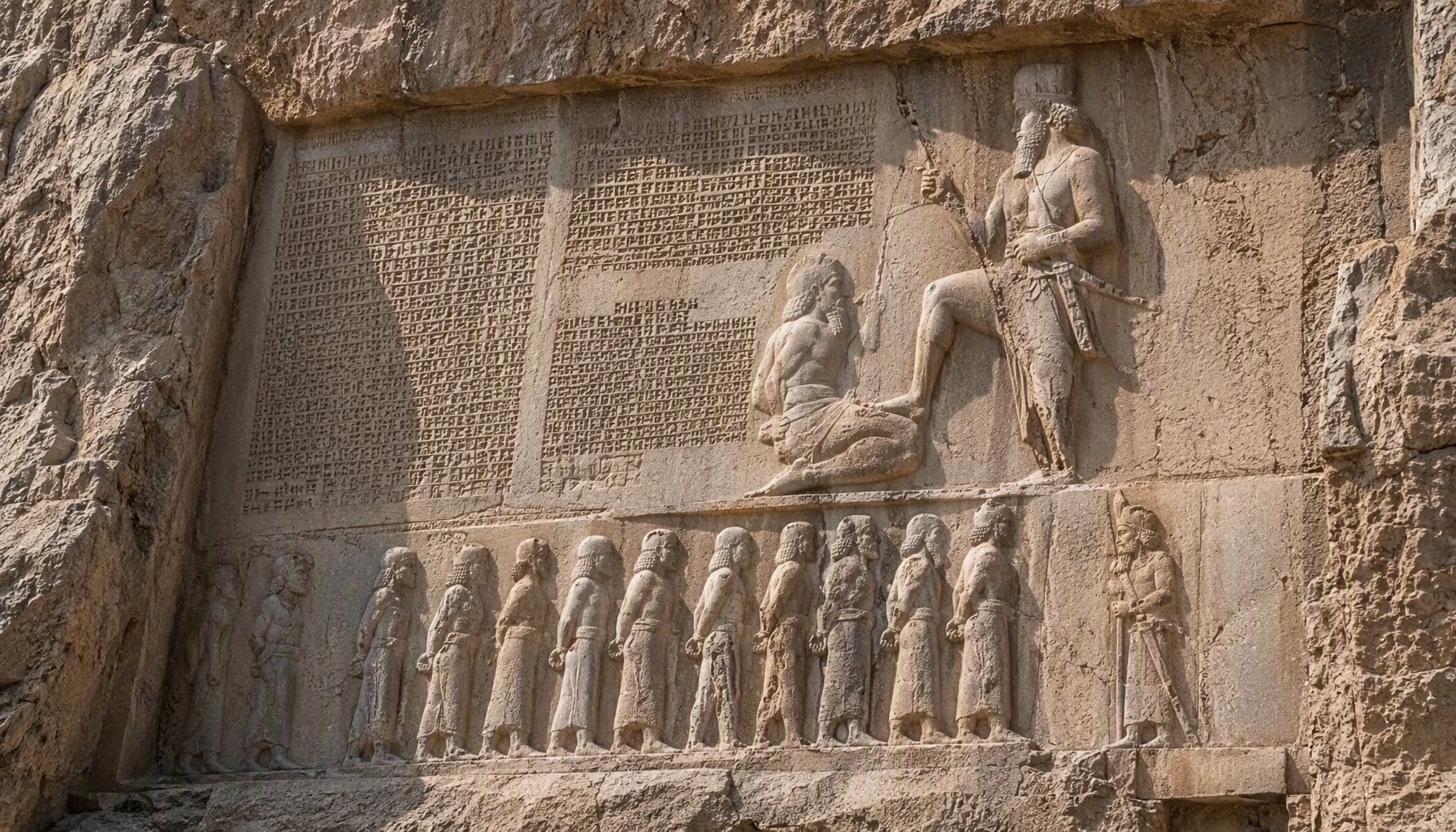
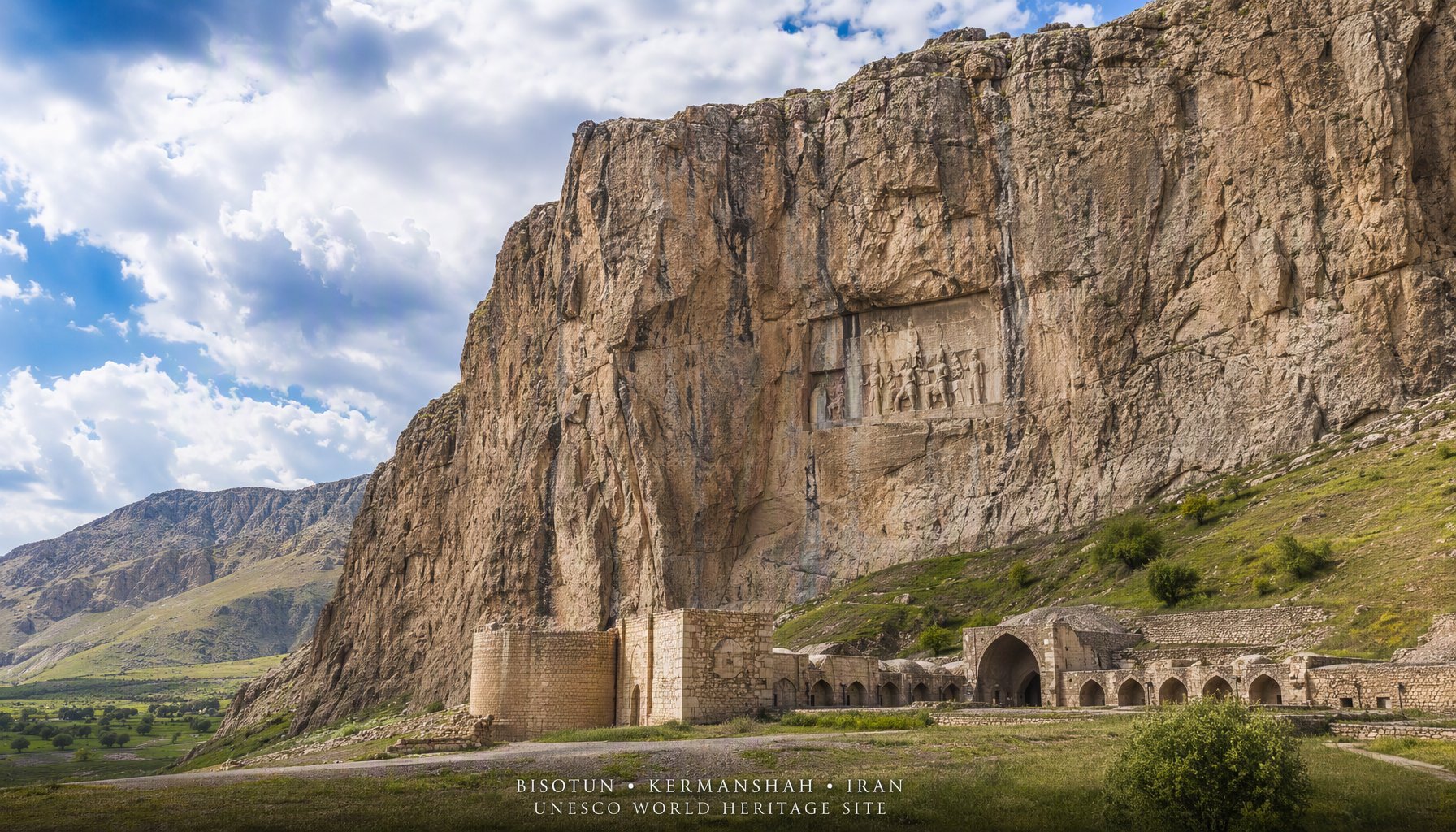
The road from Kermanshah to Hamadan crosses a flat plain that is unremarkable for the first thirty kilometres. Then the land begins to rise, the Zagros foothills crowd in from the north, and a great limestone cliff face appears on your left, rising sheer from the road. Halfway up, about a hundred metres above the ground, you see something carved into the rock: a panel of figures, a bearded king standing with his foot on the chest of a rebel, and behind the king, rows of tiny bound captives. Below the figures, lines of cuneiform script march across the stone in three different languages. This is the Bisotun Inscription, the document that gave historians the key to reading every cuneiform text ever found in Mesopotamia and Persia, and it has been on the UNESCO World Heritage List since 2006.
The significance of Bisotun is difficult to overstate. Before the inscription was deciphered in the middle of the nineteenth century, the languages of ancient Assyria and Babylonia were silent. Nobody could read the wedge-shaped marks that covered thousands of clay tablets pulled from the ruins of Nineveh and Babylon. The decipherment of the Bisotun text in Old Persian, Elamite, and Babylonian changed all of that. It was the equivalent of the Rosetta Stone for cuneiform writing, and it opened up the entire written record of the ancient Near East to modern scholarship. Every museum label you read on Assyrian or Babylonian artifacts, every history book that quotes the annals of the Assyrian kings, exists because of the work done on this cliff face in Kermanshah province.
The Inscription of Darius the Great
The text was carved on the orders of Darius I, known to history as Darius the Great, sometime between 522 and 486 BCE. Darius had come to the throne in turbulent circumstances. The death of Cyrus the Great's son, Cambyses II, had triggered a wave of revolts across the empire. Pretenders claimed the throne in Elam, in Babylonia, in Media, and in Parthia. Darius defeated them all, one by one, in a series of campaigns that he describes in meticulous detail on this very rock.
The inscription is written in three languages, each in its own version of cuneiform script. The Old Persian version contains approximately 414 lines of text, arranged in four columns. The Elamite version, positioned below the Old Persian, contains approximately 593 lines. The Babylonian version, in the deeply recessed panel to the right, contains approximately 112 lines. The repetition in three languages was not decorative. It was a deliberate act of imperial communication. Darius wanted his proclamation to be read by the Persians, by the Elamites, and by the Babylonians, the three major populations of his empire.
The content of the text is both political and religious. Darius describes how he came to power, how he defeated the usurper Gaumata (a magus who had seized the throne by claiming to be the brother of Cambyses), and how he suppressed nine rebel kings in the course of a single year. He attributes his victories to the favour of Ahuramazda, the supreme god of the Zoroastrian tradition. "By the favour of Ahuramazda," the phrase repeats again and again, as Darius lists each battle and each captured rebel. Above the scene, the winged figure of Faravahar hovers, the symbol of divine authority and perhaps of Ahuramazda himself.
The visual composition is as carefully planned as the text. In the central panel, Darius stands in a pose of victory, his left foot on the chest of Gaumata, who lies bound and supine beneath him. Behind Darius stand two attendants. Before him, in two registers, stand the bound figures of nine rebel kings, each labelled with his name and his homeland. The figures are carved in shallow relief, but the craftsmanship is precise, and the details of costume, beard, and weaponry are still readable after 2,500 years.

Henry Rawlinson and the Decipherment
The inscription had been known to Western travelers for centuries, but it was Henry Creswicke Rawlinson, a British officer of the East India Company, who undertook the dangerous and painstaking work of copying and deciphering it. Rawlinson arrived in Kermanshah in 1835, posted to the garrison town as part of his duties with the East India Company. He was an accomplished linguist with an intense interest in cuneiform, and Bisotun was the key site.
The difficulty was physical as well as intellectual. The inscription panel sits roughly 100 metres above the road, on a cliff face that offers no natural ledges or climbing routes. Rawlinson had to rig ladders and scaffolding, and on at least one occasion he had a local boy lowered by rope to copy sections that were otherwise unreachable. He worked on the text between 1835 and 1847, first copying the Old Persian version, which was the most accessible, and then the more difficult Elamite and Babylonian panels.
His breakthrough came when he recognised that the Old Persian text contained the name of Darius repeated in a pattern that matched the known genealogy of the Achaemenid kings. By using the Old Persian as a starting point, and comparing the three versions, Rawlinson and his contemporaries were able to unlock the grammar and vocabulary of all three languages. The publication of his work in the 1840s and 1850s marked the birth of Assyriology as a modern discipline. Without Bisotun, the cuneiform record of the ancient world would have remained a silent archive.
The Other Monuments at Bisotun
The Darius inscription is the centrepiece of the site, but it is not the only monument. The Bisotun complex contains traces of human activity spanning from prehistoric times to the Islamic period, and the UNESCO listing recognises the site as a palimpsest of Iranian history.
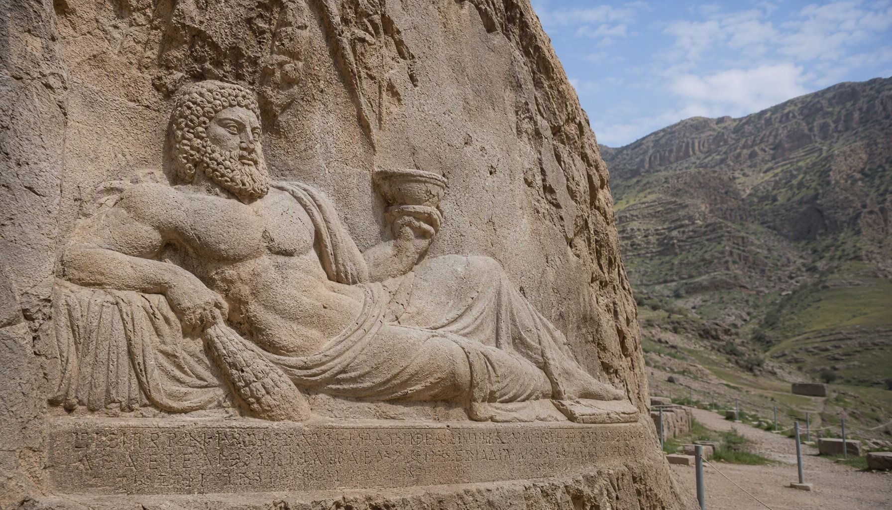
The most prominent secondary monument is the Statue of Hercules, located about 100 metres west of the main inscription. Carved in 153 BCE, during the Parthian period, the statue depicts a bearded male figure in a reclining position, holding a goblet in one hand. The figure is approximately 147 centimetres in height, and is thought to represent either the Greek hero Heracles or the Iranian god Bahram in Hellenised form. The blending of Greek and Iranian iconography is characteristic of the Parthian period, when Hellenistic artistic traditions and Iranian religious concepts coexisted and merged.
Further along the cliff face, a Parthian-era rock relief shows a king on horseback, with attendants standing before him in attitudes of respect. The relief is less famous than the Achaemenid inscription, but it testifies to the continued importance of the site long after the fall of the Achaemenid empire.
A Safavid-era caravanserai stands at the base of the cliff, a reminder that the road past Bisotun was an important trade route on the westward highway from Isfahan to Baghdad. The caravanserai is largely ruined, but its footprint and some of its walls are still visible, and it adds to the layered historical atmosphere of the site.
UNESCO World Heritage Status
Bisotun was inscribed on the UNESCO World Heritage List in 2006, under criterion (iii), as a unique testimony to a cultural tradition that played a decisive role in the history of human civilisation. The UNESCO citation recognises the inscription not only as a monument of the Achaemenid period, but as the key document that made the decipherment of cuneiform writing possible. The site covers an area of 187 hectares, with a buffer zone of 134 hectares, and includes the inscription panel, the Hercules statue, the Parthian relief, the Safavid caravanserai, and the surrounding natural landscape of the Zagros foothills.
The management of the site is the responsibility of the Iranian Cultural Heritage, Handicrafts and Tourism Organization (ICHHTO). Visitor access to the inscription panel itself is restricted, because the cliff face is too steep and fragile for regular climbing. Viewing is from a platform at the base of the cliff, where the figures and the beginning of the text are visible with the naked eye. Binoculars or a telephoto lens are recommended for close reading of the cuneiform lines.
How to Get to Bisotun
The site is located approximately 30 kilometres east of the city of Kermanshah, on the main road to Hamadan. The drive from Kermanshah takes about 30 to 40 minutes by car. Public transport options are limited, but shared taxis run along the Kermanshah-Hamadan road and can drop you at the site entrance. If you are planning your trip, Mehyar Taxi can arrange transport from Kermanshah to Bisotun, and Mehyar Buses covers the longer routes to Kermanshah from Tehran (approximately six hours) or from other western Iranian cities.
Kermanshah is a city of about 900,000 people, the largest Kurdish-speaking city in Iran, and a centre of considerable historical and cultural interest in its own right. The city has an airport, Shahid Kashani Airport, with domestic flights from Tehran. The road from Tehran to Kermanshah is about 520 kilometres and takes roughly six hours by car or bus.
Once you arrive at the site, the approach path leads from the road up to the viewing platform at the base of the cliff. The walk is short but steep in places, and sturdy shoes are recommended. There is a small visitor centre and a ticket office near the entrance.
Practical Information
The site is open daily, typically from 8:00 AM to 7:00 PM in the summer months (April through September) and 8:00 AM to 5:00 PM in the winter months (October through March). Entrance fees are modest, typically in the range of $4 to $8 USD for foreign visitors, though prices are subject to change. It is advisable to carry small denominations of Iranian rials, as card payment facilities at the site may be unreliable.
The best season to visit Bisotun is spring (March to May) or autumn (September to November). Summers in Kermanshah province are hot, with temperatures often exceeding 35 degrees Celsius, and the site offers very little shade. Winters can be cold, with occasional snow, and the road from Kermanshah can be icy. Spring brings wildflowers to the Zagros foothills, and the light in the early morning and late afternoon makes the cliff face glow with warm colour, which is the best time for photography.
Photography is freely permitted at Bisotun, and the site is one of the most photogenic historical monuments in Iran. The main inscription panel, high on the cliff with the figures of Darius and his captives, creates a striking image against the pale limestone. The Hercules statue, in its niche, is also a rewarding subject. A telephoto lens is highly recommended, as the inscription is not easily readable from ground level.
Bisotun in the Context of a Western Iran Itinerary
Bisotun sits on the main westward axis of Iran, the ancient road that connected the Persian heartland to Mesopotamia and the Mediterranean. A visit to Bisotun combines naturally with other major sites in Kermanshah province and the wider Zagros region. The Taq-e Bostan rock reliefs, about 12 kilometres northeast of Kermanshah, show Sasanian kings on horseback and are among the finest examples of Sasanian art in Iran. The Taq-e Gara rock inscription is another Sasanian monument in the vicinity.
Further afield, the road from Kermanshah to Hamadan passes through some of the most scenic countryside in western Iran, with rolling hills, walnut groves, and traditional Kurdish villages. Hamadan itself, one of the oldest continuously inhabited cities in the world, offers the tomb of Esther and Mordechai, the Avicenna Mausoleum, and the Ganjnameh inscriptions of Darius and Xerxes, which echo the great text at Bisotun on a smaller scale.
For travelers using Mehyar, a western Iran itinerary centred on Bisotun can be built around the Kermanshah to Hamadan corridor. Mehyar Flights connects Tehran to Kermanshah, and Mehyar Buses serves the intercity routes. The journey from the cuneiform cliffs of Bisotun to the Achaemenid inscriptions at Ganjnameh, and from there to the ancient capital of Ecbatana at Hamadan, traces a thread of Persian imperial history that few other routes in the world can match.